


")


DJI PHANTOM 4 RTK + D-RTK 2 MOBILE STATION COMBO FOR MAPPINGS/MAPPING INSTRUCTIONS
Product number:
9761615
Manufacturer number:
4539
GTIN/EAN:
4251522804898
Description "DJI PHANTOM 4 RTK + D-RTK 2 MOBILE STATION COMBO FOR MAPPINGS/MAPPING INSTRUCTIONS"
Please be aware that this product can only be shipped to the following countries: Austria, Germany, Switzerland, Belgium, Bulgaria, Croatia, Czech Republic, Denmark, Estonia, France, Greece, Hungary, Italy, Ireland, Luxembourg, Netherlands, Poland, Portugal, Romania, Serbia, Slovakia, Slovenia, Spain, and the United Kingdom!
Please also read our safety notice:
https://www.lindinger.at/en/navigation/37ea30801f564076831f044e67e1fa6f
Please also read our safety notice:
https://www.lindinger.at/en/navigation/37ea30801f564076831f044e67e1fa6f
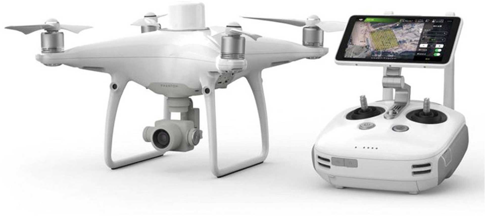
Phantom 4 RTK - Experiential intelligence. Absolute precision.
Experience the next generation of advanced mapping operations with the Phantom 4 RTK, the most compact and accurate low altitude mapping solution.
Next generation mapping
DJI has rethought modern drone technology from the ground up, creating a new standard of precision.
The Phantom 4 RTK offers customers centimeter accurate data and reduces the need for ground control points.
-1 cm + 1 ppm RTK Horizontal positioning accuracy
-1.5 cm + 1 ppm RTK Vertical positioning accuracy
5 cm* Absolute horizontal precision of photogrammetric models
Key Features
RTK Modules
-1" CMOS Sensor
GS RTK APP
TimeSync
-OcuSync
D-RTK 2 GNSS Mobile Station
Positioning system accurate to the centimeter
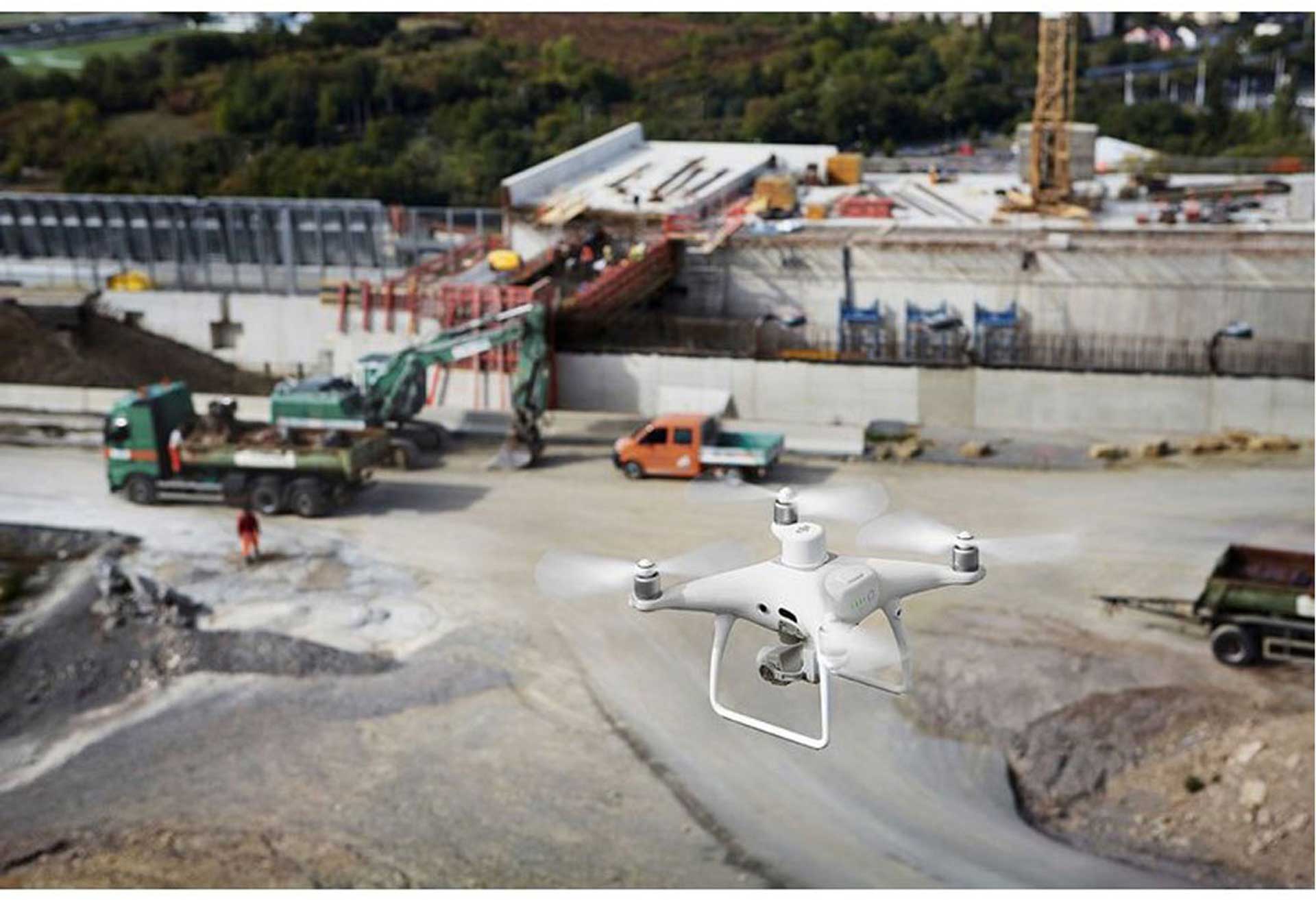
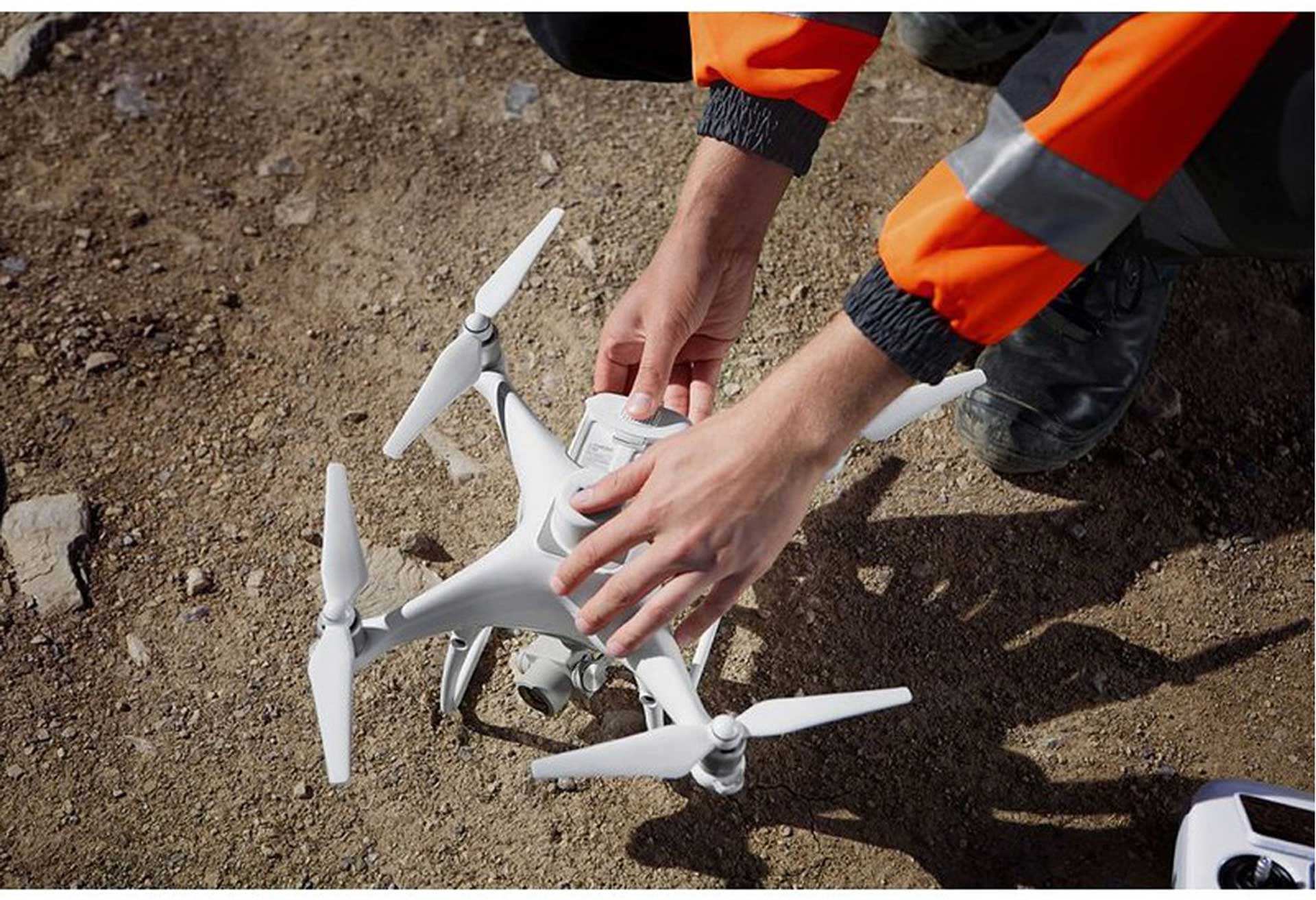
The new RTK module has been integrated directly into the Phantom 4 RTK and provides centimeter-precise position data for improved overall metadata accuracy. Redundant GNSS modules are installed directly under the RTK receiver, providing greater flight stability in areas with traditionally poor reception, such as densely built-up city centres. By combining both modules, the Phantom 4 RTK enhances flight safety and simultaneously logs precision data of complex surveys, mapping and inspections. Easily integrate the Phantom 4 RTK into professional workflows. The Phantom 4 RTK is able to easily connect to the D-RTK 2 Mobile Station, connect via NTRIP (Network Transport of RTCM via Internet Protocol) via a 4G dongle or Wi-Fi hotspot, and store satellite data for Post Processed Kinematics (PPK).
Precise data logging with TimeSync
To take full advantage of the Phantom 4 RTK's positioning modules, the new TimeSync system continuously synchronizes the flight controller, camera and RTK module data. In addition, TimeSync ensures that each photo is equipped with precise metadata and fixes the position data in the center of the CMOS - for optimal results and precision in photogrammetric methods.
Precise camera system
Capture the best image data with the 1-inch 20-megapixel CMOS sensor. The mechanical shutter ensures seamless mapping and data acquisition by eliminating rolling shutter effects. Due to the high resolution of the camera sensor, the Phantom 4 RTK is able to achieve a Ground Sample Distance (GSD) of 2.74 cm at a flight altitude of 100 m. The Phantom 4 RTK is also capable of achieving a Ground Sample Distance (GSD) of 2.74 cm. To ensure the precision of the Phantom 4 RTK, each lens undergoes a thorough calibration process to measure radial and tangential distortion. The distortion parameters are stored in the metadata of each image so that the post-processing software can be customized for each user.
Special Flight Planning App
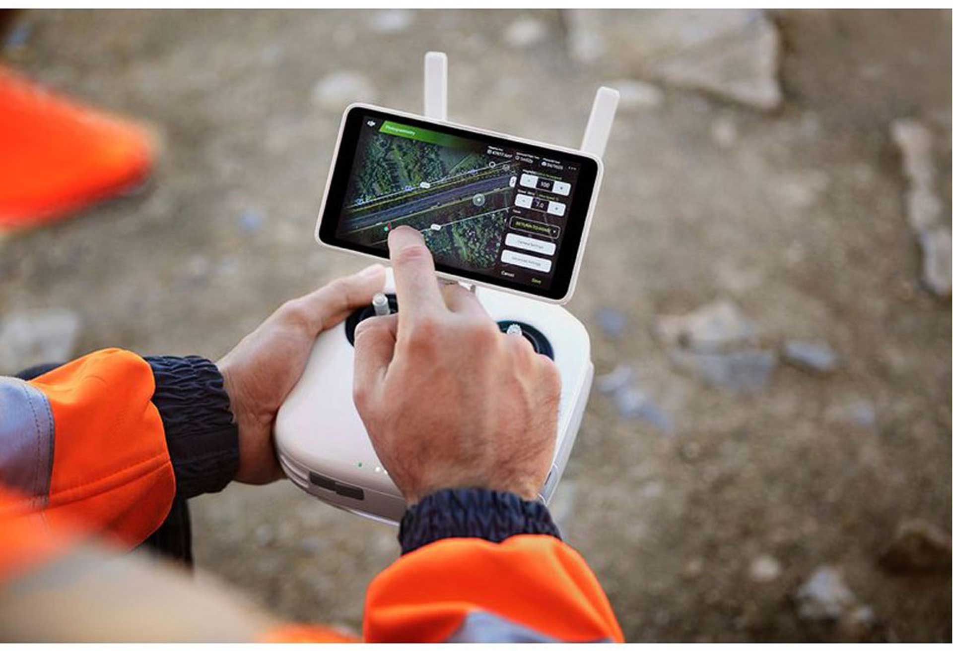
The new GS RTK App allows pilots to intelligently control the Phantom 4 RTK. In addition to the traditional flight modes, the app offers two new planning modes: photogrammetry and waypoints. The planning modes allow automated workflows by allowing pilots to determine the drone's flight path, while parameters such as overlap rate, altitude, airspeed and camera settings can be easily set. The GS RTK App has been developed specifically for the end user and therefore offers various functions specifically designed for mapping and inspection. The app is able to load KML files directly and thus allows the planning of flight routes already in the office. A new automatic aperture mode keeps the exposure constant for all photos and wind warnings inform about unfavourable shooting conditions.
Support for Mobile SDK
The Phantom 4 RTK is compatible with the DJI Mobile SDK, allowing even more automation and customization options in combination with a mobile device.
OcuSync image transmission system
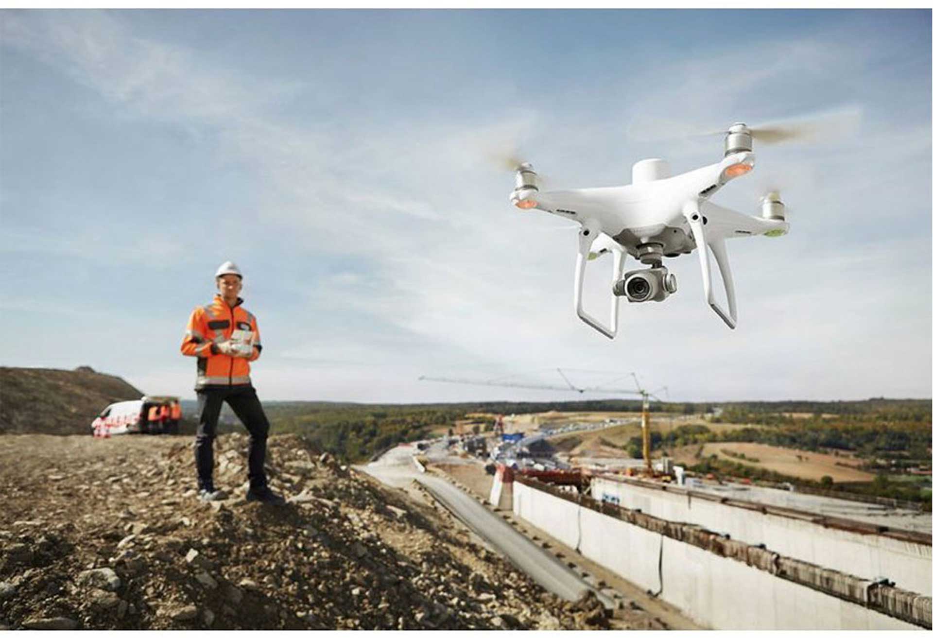
Enjoy reliable HD image and video transmission with a range of up to 7 km. Without obstacles and interference, FCC compliant Maximum flight distance is a reference value for signal strength and robustness. Unless otherwise permitted, a drone should always be flown with visual contact.
Seamless compatibility with the D-RTK 2 Mobile Station
Support the Phantom 4 RTK missions with a D-RTK 2 Mobile Station - for real-time differential data transmission. The rugged design of the Mobile Station and OcuSync 2.0 offer centimeter-accurate precision under the most adverse conditions.
Invest now in modern workflows
With an integrated flight planning app (GS RTK) and a simple method to collect RTK data (RTK Network or D-RTK 2 Mobile Station), pilots have a comprehensive solution for surveying, mapping, and
Experience the next generation of advanced mapping operations with the Phantom 4 RTK, the most compact and accurate low altitude mapping solution.
Next generation mapping
DJI has rethought modern drone technology from the ground up, creating a new standard of precision.
The Phantom 4 RTK offers customers centimeter accurate data and reduces the need for ground control points.
-1 cm + 1 ppm RTK Horizontal positioning accuracy
-1.5 cm + 1 ppm RTK Vertical positioning accuracy
5 cm* Absolute horizontal precision of photogrammetric models
Key Features
RTK Modules
-1" CMOS Sensor
GS RTK APP
TimeSync
-OcuSync
D-RTK 2 GNSS Mobile Station
Positioning system accurate to the centimeter
The new RTK module has been integrated directly into the Phantom 4 RTK and provides centimeter-precise position data for improved overall metadata accuracy. Redundant GNSS modules are installed directly under the RTK receiver, providing greater flight stability in areas with traditionally poor reception, such as densely built-up city centres. By combining both modules, the Phantom 4 RTK enhances flight safety and simultaneously logs precision data of complex surveys, mapping and inspections. Easily integrate the Phantom 4 RTK into professional workflows. The Phantom 4 RTK is able to easily connect to the D-RTK 2 Mobile Station, connect via NTRIP (Network Transport of RTCM via Internet Protocol) via a 4G dongle or Wi-Fi hotspot, and store satellite data for Post Processed Kinematics (PPK).
Precise data logging with TimeSync
To take full advantage of the Phantom 4 RTK's positioning modules, the new TimeSync system continuously synchronizes the flight controller, camera and RTK module data. In addition, TimeSync ensures that each photo is equipped with precise metadata and fixes the position data in the center of the CMOS - for optimal results and precision in photogrammetric methods.
Precise camera system
Capture the best image data with the 1-inch 20-megapixel CMOS sensor. The mechanical shutter ensures seamless mapping and data acquisition by eliminating rolling shutter effects. Due to the high resolution of the camera sensor, the Phantom 4 RTK is able to achieve a Ground Sample Distance (GSD) of 2.74 cm at a flight altitude of 100 m. The Phantom 4 RTK is also capable of achieving a Ground Sample Distance (GSD) of 2.74 cm. To ensure the precision of the Phantom 4 RTK, each lens undergoes a thorough calibration process to measure radial and tangential distortion. The distortion parameters are stored in the metadata of each image so that the post-processing software can be customized for each user.
Special Flight Planning App
The new GS RTK App allows pilots to intelligently control the Phantom 4 RTK. In addition to the traditional flight modes, the app offers two new planning modes: photogrammetry and waypoints. The planning modes allow automated workflows by allowing pilots to determine the drone's flight path, while parameters such as overlap rate, altitude, airspeed and camera settings can be easily set. The GS RTK App has been developed specifically for the end user and therefore offers various functions specifically designed for mapping and inspection. The app is able to load KML files directly and thus allows the planning of flight routes already in the office. A new automatic aperture mode keeps the exposure constant for all photos and wind warnings inform about unfavourable shooting conditions.
Support for Mobile SDK
The Phantom 4 RTK is compatible with the DJI Mobile SDK, allowing even more automation and customization options in combination with a mobile device.
OcuSync image transmission system
Enjoy reliable HD image and video transmission with a range of up to 7 km. Without obstacles and interference, FCC compliant Maximum flight distance is a reference value for signal strength and robustness. Unless otherwise permitted, a drone should always be flown with visual contact.
Seamless compatibility with the D-RTK 2 Mobile Station
Support the Phantom 4 RTK missions with a D-RTK 2 Mobile Station - for real-time differential data transmission. The rugged design of the Mobile Station and OcuSync 2.0 offer centimeter-accurate precision under the most adverse conditions.
Invest now in modern workflows
With an integrated flight planning app (GS RTK) and a simple method to collect RTK data (RTK Network or D-RTK 2 Mobile Station), pilots have a comprehensive solution for surveying, mapping, and
Technical data
| Length (mm): | - |
|---|